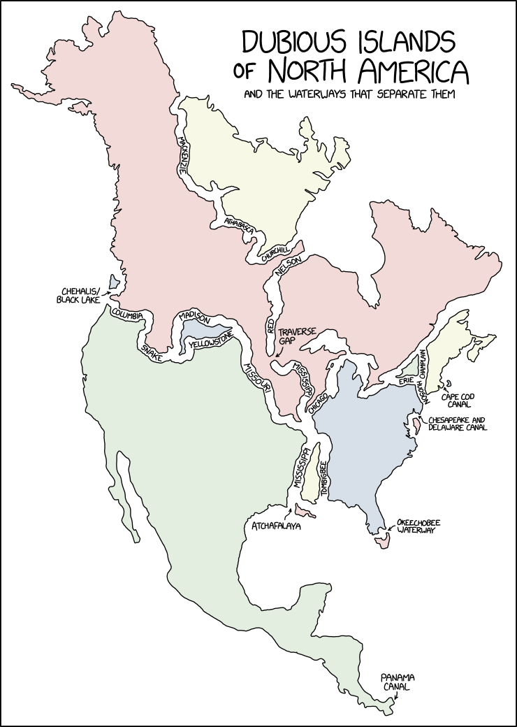
▲ 277 ▼ xkcd: Dubious Islands (imgs.xkcd.com) submitted 2 years ago by otter@lemmy.ca [M] to c/comicstrips@lemmy.world 25 comments fedilink hide all child comments Source: https://xkcd.com/2838/
[–] SoylentBlake@lemm.ee 21 points 2 years ago* (1 child) "XKCD is usually more astute. The lack of the Colorado River, and The Grand Canyon, is a glaring omission." Does the Colorado cut off a land mass? I don't think the Colorado even reaches the sea anymore, let alone psuesocleave apart a part of the continent. That was a fun last sentence to say. permalink fedilink source parent hideshow 2 child comments replies: [–] antlion@lemmy.dbzer0.com -1 points 2 years ago (1 child) What could possibly cleave the continent more than the Grand Canyon? In many places it’s a barrier that can’t be crossed except by flight. It’s a prominent river until Yuma, AZ, which is not too far from the Gulf of California. And even if the water doesn’t always flow, it forms the boundary between the Mexican states of Baja and Sonora. permalink fedilink source parent hideshow 2 child comments replies: [–] CodeInvasion@sh.itjust.works 3 points 2 years ago (1 child) Yes, but you fail to understand the difference between a peninsula and a psuedo-island (a piece of land entirely surrounded by any body of water, artificial or manmade). The Colorado River starts in Colorado is does not flow over the continental divide. permalink fedilink source parent hideshow 2 child comments replies: [–] antlion@lemmy.dbzer0.com 1 point 2 years ago (1 child) No river can be traced all the way up to a dividing ridge. As the contributing drainage area gets smaller it will be a stream, then creek, trickle, gulley, and by the time it’s on a mountain ridge it’s nothing. permalink fedilink source parent hideshow 2 child comments replies: [–] CodeInvasion@sh.itjust.works 3 points 2 years ago You would think so, but there is one river that happens to flow and split over the continental divide called North Two Ocean Creek. It’s the tiniest technicality that makes this map technically true. https://en.wikipedia.org/wiki/Two_Ocean_Pass permalink fedilink source parent
[–] antlion@lemmy.dbzer0.com -1 points 2 years ago (1 child) What could possibly cleave the continent more than the Grand Canyon? In many places it’s a barrier that can’t be crossed except by flight. It’s a prominent river until Yuma, AZ, which is not too far from the Gulf of California. And even if the water doesn’t always flow, it forms the boundary between the Mexican states of Baja and Sonora. permalink fedilink source parent hideshow 2 child comments replies: [–] CodeInvasion@sh.itjust.works 3 points 2 years ago (1 child) Yes, but you fail to understand the difference between a peninsula and a psuedo-island (a piece of land entirely surrounded by any body of water, artificial or manmade). The Colorado River starts in Colorado is does not flow over the continental divide. permalink fedilink source parent hideshow 2 child comments replies: [–] antlion@lemmy.dbzer0.com 1 point 2 years ago (1 child) No river can be traced all the way up to a dividing ridge. As the contributing drainage area gets smaller it will be a stream, then creek, trickle, gulley, and by the time it’s on a mountain ridge it’s nothing. permalink fedilink source parent hideshow 2 child comments replies: [–] CodeInvasion@sh.itjust.works 3 points 2 years ago You would think so, but there is one river that happens to flow and split over the continental divide called North Two Ocean Creek. It’s the tiniest technicality that makes this map technically true. https://en.wikipedia.org/wiki/Two_Ocean_Pass permalink fedilink source parent
[–] CodeInvasion@sh.itjust.works 3 points 2 years ago (1 child) Yes, but you fail to understand the difference between a peninsula and a psuedo-island (a piece of land entirely surrounded by any body of water, artificial or manmade). The Colorado River starts in Colorado is does not flow over the continental divide. permalink fedilink source parent hideshow 2 child comments replies: [–] antlion@lemmy.dbzer0.com 1 point 2 years ago (1 child) No river can be traced all the way up to a dividing ridge. As the contributing drainage area gets smaller it will be a stream, then creek, trickle, gulley, and by the time it’s on a mountain ridge it’s nothing. permalink fedilink source parent hideshow 2 child comments replies: [–] CodeInvasion@sh.itjust.works 3 points 2 years ago You would think so, but there is one river that happens to flow and split over the continental divide called North Two Ocean Creek. It’s the tiniest technicality that makes this map technically true. https://en.wikipedia.org/wiki/Two_Ocean_Pass permalink fedilink source parent
[–] antlion@lemmy.dbzer0.com 1 point 2 years ago (1 child) No river can be traced all the way up to a dividing ridge. As the contributing drainage area gets smaller it will be a stream, then creek, trickle, gulley, and by the time it’s on a mountain ridge it’s nothing. permalink fedilink source parent hideshow 2 child comments replies: [–] CodeInvasion@sh.itjust.works 3 points 2 years ago You would think so, but there is one river that happens to flow and split over the continental divide called North Two Ocean Creek. It’s the tiniest technicality that makes this map technically true. https://en.wikipedia.org/wiki/Two_Ocean_Pass permalink fedilink source parent
[–] CodeInvasion@sh.itjust.works 3 points 2 years ago You would think so, but there is one river that happens to flow and split over the continental divide called North Two Ocean Creek. It’s the tiniest technicality that makes this map technically true. https://en.wikipedia.org/wiki/Two_Ocean_Pass permalink fedilink source parent