▲ 326 ▼ African Union joins calls to end use of Mercator map that shrinks continent’s size (www.theguardian.com) submitted 1 year ago by Davriellelouna@lemmy.world to c/world@lemmy.world 83 comments fedilink hide all child comments
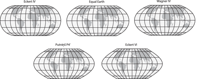
[–] kopasz7@sh.itjust.works 86 points 1 year ago (3 children) “It’s [the Mercator projection] the world’s longest misinformation and disinformation campaign, and it just simply has to stop.” No matter how we cut it though, all 2D projections will have some kind of distortion. They opted to preserve area, while the Mercator preserves angles. Arguably it is less important today to preserve angles, as we have automatic navigation systems. There are some alternatives that also preserve the area: https://upload.wikimedia.org/wikipedia/commons/7/76/The-Equal-Earth-compared-to-similar-equal-area-pseudocylindrical-projections.png permalink fedilink source hideshow 6 child comments replies: [–] QuarterSwede@lemmy.world 26 points 1 year ago (1 child) Right. What people need to understand that any globe put on a flat surface will be distorted. Their proposal is just as distorted as the Mercator, just in area vs angles as you stated. permalink fedilink source parent hideshow 2 child comments replies: [–] Texas_Hangover@lemmy.radio 3 points 1 year ago (1 child) Its a good thing you came along to reiterate that. permalink fedilink source parent hideshow 2 child comments replies: [–] mika_mika@lemmy.world 3 points 1 year ago Just fyi this 2D projection is also distorted just in angles instead of area. permalink fedilink source parent [–] CanadaPlus@lemmy.sdf.org 14 points 1 year ago It's not a damn campaign. Activists never seem to be good at nuance. permalink fedilink source parent [+] Pacattack57@lemmy.world -18 points 1 year ago* (last edited 1 year ago) (4 children) The Mercator is a propaganda campaign to make Christian countries look big and powerful. Ask yourself why is it only “Christian” countries that are distorted. Edit: should have put this /s permalink fedilink source parent hideshow 8 child comments replies: [–] ChairmanMeow@programming.dev 19 points 1 year ago Maps were used for navigation, which meant angles needed to be preserved. Christian nations colonised a lot, meaning they needed to have maps for navigation a lot too. This isn't some weird propaganda campaign, that makes no sense. Try making an angle-preserving map that doesn't wildly distort the north and south of the world. Besides, not sure how Christian the icy wastes of Greenland and Antarctica are. permalink fedilink source parent [–] Flipper@feddit.org 14 points 1 year ago (2 children) The Mercator projection is good in what it was made for: Navigation. You know. The whole purpose of maps. permalink fedilink source parent hideshow 4 child comments replies: [–] sugarfoot00@lemmy.ca 1 point 1 year ago Navigation isn't the only purpose of maps. You can display geographical, social, economic, and a whole host of other datasets on to maps. And since maps with fidelity to lat/long lines are no longer a requirement for navigation, there's a good argument for accurately displaying relative positioning and size. permalink fedilink source parent [–] Zaktor@sopuli.xyz 0 points 1 year ago When was the last time you used a global map for navigation? It's not even terribly good for that, as when traveling at global scales, most of us travel along great circle paths that end up looking wrong on the Mercator protection. permalink fedilink source parent [–] kopasz7@sh.itjust.works 5 points 1 year ago* I know right! It's all done to further Antarctica's hegemony! Just look how huge it seems! /uj If you want no distortions, get a globe. permalink fedilink source parent [–] RaivoKulli@sopuli.xyz 2 points 1 year ago (1 child) But what about Latin America and Christians parts of Africa permalink fedilink source parent hideshow 2 child comments replies: [–] Pacattack57@lemmy.world 1 point 1 year ago Those are inferior skin colors so they’re excluded. I added to the original comment but I’m trolling lol permalink fedilink source parent
[–] QuarterSwede@lemmy.world 26 points 1 year ago (1 child) Right. What people need to understand that any globe put on a flat surface will be distorted. Their proposal is just as distorted as the Mercator, just in area vs angles as you stated. permalink fedilink source parent hideshow 2 child comments replies: [–] Texas_Hangover@lemmy.radio 3 points 1 year ago (1 child) Its a good thing you came along to reiterate that. permalink fedilink source parent hideshow 2 child comments replies: [–] mika_mika@lemmy.world 3 points 1 year ago Just fyi this 2D projection is also distorted just in angles instead of area. permalink fedilink source parent
[–] Texas_Hangover@lemmy.radio 3 points 1 year ago (1 child) Its a good thing you came along to reiterate that. permalink fedilink source parent hideshow 2 child comments replies: [–] mika_mika@lemmy.world 3 points 1 year ago Just fyi this 2D projection is also distorted just in angles instead of area. permalink fedilink source parent
[–] mika_mika@lemmy.world 3 points 1 year ago Just fyi this 2D projection is also distorted just in angles instead of area. permalink fedilink source parent
[–] CanadaPlus@lemmy.sdf.org 14 points 1 year ago It's not a damn campaign. Activists never seem to be good at nuance. permalink fedilink source parent
[+] Pacattack57@lemmy.world -18 points 1 year ago* (last edited 1 year ago) (4 children) The Mercator is a propaganda campaign to make Christian countries look big and powerful. Ask yourself why is it only “Christian” countries that are distorted. Edit: should have put this /s permalink fedilink source parent hideshow 8 child comments replies: [–] ChairmanMeow@programming.dev 19 points 1 year ago Maps were used for navigation, which meant angles needed to be preserved. Christian nations colonised a lot, meaning they needed to have maps for navigation a lot too. This isn't some weird propaganda campaign, that makes no sense. Try making an angle-preserving map that doesn't wildly distort the north and south of the world. Besides, not sure how Christian the icy wastes of Greenland and Antarctica are. permalink fedilink source parent [–] Flipper@feddit.org 14 points 1 year ago (2 children) The Mercator projection is good in what it was made for: Navigation. You know. The whole purpose of maps. permalink fedilink source parent hideshow 4 child comments replies: [–] sugarfoot00@lemmy.ca 1 point 1 year ago Navigation isn't the only purpose of maps. You can display geographical, social, economic, and a whole host of other datasets on to maps. And since maps with fidelity to lat/long lines are no longer a requirement for navigation, there's a good argument for accurately displaying relative positioning and size. permalink fedilink source parent [–] Zaktor@sopuli.xyz 0 points 1 year ago When was the last time you used a global map for navigation? It's not even terribly good for that, as when traveling at global scales, most of us travel along great circle paths that end up looking wrong on the Mercator protection. permalink fedilink source parent [–] kopasz7@sh.itjust.works 5 points 1 year ago* I know right! It's all done to further Antarctica's hegemony! Just look how huge it seems! /uj If you want no distortions, get a globe. permalink fedilink source parent [–] RaivoKulli@sopuli.xyz 2 points 1 year ago (1 child) But what about Latin America and Christians parts of Africa permalink fedilink source parent hideshow 2 child comments replies: [–] Pacattack57@lemmy.world 1 point 1 year ago Those are inferior skin colors so they’re excluded. I added to the original comment but I’m trolling lol permalink fedilink source parent
[–] ChairmanMeow@programming.dev 19 points 1 year ago Maps were used for navigation, which meant angles needed to be preserved. Christian nations colonised a lot, meaning they needed to have maps for navigation a lot too. This isn't some weird propaganda campaign, that makes no sense. Try making an angle-preserving map that doesn't wildly distort the north and south of the world. Besides, not sure how Christian the icy wastes of Greenland and Antarctica are. permalink fedilink source parent
[–] Flipper@feddit.org 14 points 1 year ago (2 children) The Mercator projection is good in what it was made for: Navigation. You know. The whole purpose of maps. permalink fedilink source parent hideshow 4 child comments replies: [–] sugarfoot00@lemmy.ca 1 point 1 year ago Navigation isn't the only purpose of maps. You can display geographical, social, economic, and a whole host of other datasets on to maps. And since maps with fidelity to lat/long lines are no longer a requirement for navigation, there's a good argument for accurately displaying relative positioning and size. permalink fedilink source parent [–] Zaktor@sopuli.xyz 0 points 1 year ago When was the last time you used a global map for navigation? It's not even terribly good for that, as when traveling at global scales, most of us travel along great circle paths that end up looking wrong on the Mercator protection. permalink fedilink source parent
[–] sugarfoot00@lemmy.ca 1 point 1 year ago Navigation isn't the only purpose of maps. You can display geographical, social, economic, and a whole host of other datasets on to maps. And since maps with fidelity to lat/long lines are no longer a requirement for navigation, there's a good argument for accurately displaying relative positioning and size. permalink fedilink source parent
[–] Zaktor@sopuli.xyz 0 points 1 year ago When was the last time you used a global map for navigation? It's not even terribly good for that, as when traveling at global scales, most of us travel along great circle paths that end up looking wrong on the Mercator protection. permalink fedilink source parent
[–] kopasz7@sh.itjust.works 5 points 1 year ago* I know right! It's all done to further Antarctica's hegemony! Just look how huge it seems! /uj If you want no distortions, get a globe. permalink fedilink source parent
[–] RaivoKulli@sopuli.xyz 2 points 1 year ago (1 child) But what about Latin America and Christians parts of Africa permalink fedilink source parent hideshow 2 child comments replies: [–] Pacattack57@lemmy.world 1 point 1 year ago Those are inferior skin colors so they’re excluded. I added to the original comment but I’m trolling lol permalink fedilink source parent
[–] Pacattack57@lemmy.world 1 point 1 year ago Those are inferior skin colors so they’re excluded. I added to the original comment but I’m trolling lol permalink fedilink source parent