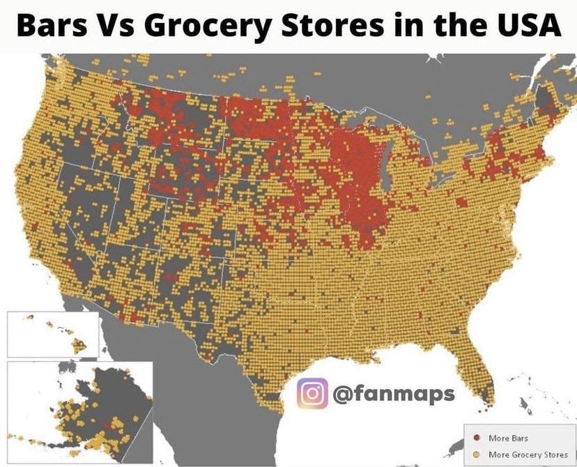
▲ 272 ▼ Bars vs Grocery Stores in the United States (lemmy.world) submitted 2 years ago by The_Picard_Maneuver@lemmy.world to c/map_enthusiasts@sopuli.xyz 52 comments fedilink hide all child comments
[–] Lemjukes@lemm.ee 99 points 2 years ago* (9 children) I think this is a bad map. No data, no sourcing, no analysis, nothing. It’s just clickbaity nonsense. Those aren’t even counties it’s just cutting the country up into random squares cause lord knows how forked the map projection is. permalink fedilink source hideshow 9 child comments replies: [–] noodlejetski@lemm.ee 51 points 2 years ago (8 children) Those aren’t even counties it’s just cutting the country up into random squares hey, if it works for voting permalink fedilink source parent hideshow 8 child comments replies: [–] Fuck_u_spez_@sh.itjust.works 25 points 2 years ago (6 children) "Squares". permalink fedilink source parent hideshow 6 child comments replies: [–] pm_me_your_thoughts@lemmy.world 4 points 2 years ago (1 child) They're not even being subtle. What's their excuse? permalink fedilink source parent hideshow 1 child comment replies: [–] bleistift2@sopuli.xyz 0 points 2 years ago It’s not always gerrymandering. See my response to @Fuck_u_spez_@sh.itjust.works. permalink fedilink source parent [–] roguetrick@lemmy.world 2 points 2 years ago* Maryland's sixth used to be pretty hilarious too. They put an urban center connected to an Appalachian rural expanse with a little corridor to drown out the rural votes. It's a little less nonsensical nowadays though. The third doesn't look like that anymore btw. It's a solid block now. permalink fedilink source parent [–] bleistift2@sopuli.xyz 1 point 2 years ago No. 3 is actually the opposite of gerrymandering. That “headphone district” connects two Latino communities https://youtu.be/A-4dIImaodQ?t=833 permalink fedilink source parent [–] LovableSidekick@lemmy.world 1 point 2 years ago* (1 child) LOL how is Maryland gerrymandered, isn't it like 12 blocks? permalink fedilink source parent hideshow 1 child comment replies: [–] roguetrick@lemmy.world 1 point 2 years ago* (last edited 2 years ago) It used to be gerrymandered to fuck. It was only recently rectified. Old New They were packing urban districts and cutting up rural districts to make safe seats. How the sixth and the eighth cut up Montgomery county to give it far flung rural districts was particularly funny. The first was a dedicated Republican seat so they purely packed the Eastern shore and other rural areas in it. Sixth used to be a Republican district before they packed urban Montgomery county into it. The sixth is competitive now that it doesn't have a big chunk of Rockville in it. permalink fedilink source parent [–] Lemjukes@lemm.ee 17 points 2 years ago Yeah but it doesn’t so… permalink fedilink source parent
[–] noodlejetski@lemm.ee 51 points 2 years ago (8 children) Those aren’t even counties it’s just cutting the country up into random squares hey, if it works for voting permalink fedilink source parent hideshow 8 child comments replies: [–] Fuck_u_spez_@sh.itjust.works 25 points 2 years ago (6 children) "Squares". permalink fedilink source parent hideshow 6 child comments replies: [–] pm_me_your_thoughts@lemmy.world 4 points 2 years ago (1 child) They're not even being subtle. What's their excuse? permalink fedilink source parent hideshow 1 child comment replies: [–] bleistift2@sopuli.xyz 0 points 2 years ago It’s not always gerrymandering. See my response to @Fuck_u_spez_@sh.itjust.works. permalink fedilink source parent [–] roguetrick@lemmy.world 2 points 2 years ago* Maryland's sixth used to be pretty hilarious too. They put an urban center connected to an Appalachian rural expanse with a little corridor to drown out the rural votes. It's a little less nonsensical nowadays though. The third doesn't look like that anymore btw. It's a solid block now. permalink fedilink source parent [–] bleistift2@sopuli.xyz 1 point 2 years ago No. 3 is actually the opposite of gerrymandering. That “headphone district” connects two Latino communities https://youtu.be/A-4dIImaodQ?t=833 permalink fedilink source parent [–] LovableSidekick@lemmy.world 1 point 2 years ago* (1 child) LOL how is Maryland gerrymandered, isn't it like 12 blocks? permalink fedilink source parent hideshow 1 child comment replies: [–] roguetrick@lemmy.world 1 point 2 years ago* (last edited 2 years ago) It used to be gerrymandered to fuck. It was only recently rectified. Old New They were packing urban districts and cutting up rural districts to make safe seats. How the sixth and the eighth cut up Montgomery county to give it far flung rural districts was particularly funny. The first was a dedicated Republican seat so they purely packed the Eastern shore and other rural areas in it. Sixth used to be a Republican district before they packed urban Montgomery county into it. The sixth is competitive now that it doesn't have a big chunk of Rockville in it. permalink fedilink source parent [–] Lemjukes@lemm.ee 17 points 2 years ago Yeah but it doesn’t so… permalink fedilink source parent
[–] Fuck_u_spez_@sh.itjust.works 25 points 2 years ago (6 children) "Squares". permalink fedilink source parent hideshow 6 child comments replies: [–] pm_me_your_thoughts@lemmy.world 4 points 2 years ago (1 child) They're not even being subtle. What's their excuse? permalink fedilink source parent hideshow 1 child comment replies: [–] bleistift2@sopuli.xyz 0 points 2 years ago It’s not always gerrymandering. See my response to @Fuck_u_spez_@sh.itjust.works. permalink fedilink source parent [–] roguetrick@lemmy.world 2 points 2 years ago* Maryland's sixth used to be pretty hilarious too. They put an urban center connected to an Appalachian rural expanse with a little corridor to drown out the rural votes. It's a little less nonsensical nowadays though. The third doesn't look like that anymore btw. It's a solid block now. permalink fedilink source parent [–] bleistift2@sopuli.xyz 1 point 2 years ago No. 3 is actually the opposite of gerrymandering. That “headphone district” connects two Latino communities https://youtu.be/A-4dIImaodQ?t=833 permalink fedilink source parent [–] LovableSidekick@lemmy.world 1 point 2 years ago* (1 child) LOL how is Maryland gerrymandered, isn't it like 12 blocks? permalink fedilink source parent hideshow 1 child comment replies: [–] roguetrick@lemmy.world 1 point 2 years ago* (last edited 2 years ago) It used to be gerrymandered to fuck. It was only recently rectified. Old New They were packing urban districts and cutting up rural districts to make safe seats. How the sixth and the eighth cut up Montgomery county to give it far flung rural districts was particularly funny. The first was a dedicated Republican seat so they purely packed the Eastern shore and other rural areas in it. Sixth used to be a Republican district before they packed urban Montgomery county into it. The sixth is competitive now that it doesn't have a big chunk of Rockville in it. permalink fedilink source parent
[–] pm_me_your_thoughts@lemmy.world 4 points 2 years ago (1 child) They're not even being subtle. What's their excuse? permalink fedilink source parent hideshow 1 child comment replies: [–] bleistift2@sopuli.xyz 0 points 2 years ago It’s not always gerrymandering. See my response to @Fuck_u_spez_@sh.itjust.works. permalink fedilink source parent
[–] bleistift2@sopuli.xyz 0 points 2 years ago It’s not always gerrymandering. See my response to @Fuck_u_spez_@sh.itjust.works. permalink fedilink source parent
[–] roguetrick@lemmy.world 2 points 2 years ago* Maryland's sixth used to be pretty hilarious too. They put an urban center connected to an Appalachian rural expanse with a little corridor to drown out the rural votes. It's a little less nonsensical nowadays though. The third doesn't look like that anymore btw. It's a solid block now. permalink fedilink source parent
[–] bleistift2@sopuli.xyz 1 point 2 years ago No. 3 is actually the opposite of gerrymandering. That “headphone district” connects two Latino communities https://youtu.be/A-4dIImaodQ?t=833 permalink fedilink source parent
[–] LovableSidekick@lemmy.world 1 point 2 years ago* (1 child) LOL how is Maryland gerrymandered, isn't it like 12 blocks? permalink fedilink source parent hideshow 1 child comment replies: [–] roguetrick@lemmy.world 1 point 2 years ago* (last edited 2 years ago) It used to be gerrymandered to fuck. It was only recently rectified. Old New They were packing urban districts and cutting up rural districts to make safe seats. How the sixth and the eighth cut up Montgomery county to give it far flung rural districts was particularly funny. The first was a dedicated Republican seat so they purely packed the Eastern shore and other rural areas in it. Sixth used to be a Republican district before they packed urban Montgomery county into it. The sixth is competitive now that it doesn't have a big chunk of Rockville in it. permalink fedilink source parent
[–] roguetrick@lemmy.world 1 point 2 years ago* (last edited 2 years ago) It used to be gerrymandered to fuck. It was only recently rectified. Old New They were packing urban districts and cutting up rural districts to make safe seats. How the sixth and the eighth cut up Montgomery county to give it far flung rural districts was particularly funny. The first was a dedicated Republican seat so they purely packed the Eastern shore and other rural areas in it. Sixth used to be a Republican district before they packed urban Montgomery county into it. The sixth is competitive now that it doesn't have a big chunk of Rockville in it. permalink fedilink source parent